

Track Navigator

Track Navigator의 설명
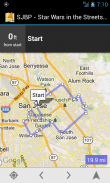
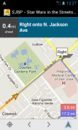
Standard navigation apps are designed to find the most direct route from point A to point B. Track Navigator is a different kind of navigation app that is designed to help you follow a pre-determined route (track) created for another purpose, such as exercise or sight-seeing. Common types of tracks include hiking trails, cycling tours, or motorcycle rides. With Track Navigator, you can:
• Find nearby tracks or import your own
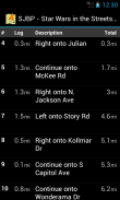
• Examine the track on a map or as a list of waypoints
• Use GPS to chart your progress following the track
• Automatically determine the next waypoint on the track
• Receive voice prompts as you approach waypoints on the track
Track Navigator supports importing tracks directly fromhttp://www.ridewithgps.com. Find nearby tracks or create your own and import them directly into Track Navigator. Tracks created using ridewithgps.com can be configured with waypoints that will provide turn-by-turn directions. Receive directions using voice prompts or view them in cue sheet format.
You can also create tracks using any other application, save them to your external storage, and import them directly into Track Navigator. Track Navigator supports importing files in GPX and TCX formats.
Other features of Track Navigator include:
• Support for metric and imperial distance units
• Highlight portions of the track that have been covered
• Voice notifications when going off track
• Display covered and remaining track distance in real-time
• Option to view satellite map
• Load individual waypoints into Google Maps for direct navigation
Many more features on the way. Stay on track with Track Navigator.표준 탐색 응용 프로그램은 B. 트랙 네비게이터를 가리 키도록하면 같은 운동과 같은 다른 목적을 위해 만든 미리 정해진 경로 (트랙), 수행 할 수 있도록 설계 탐색 응용 프로그램의 다른 종류 지점에서 가장 직접적인 경로를 찾을 수 있도록 설계되었습니다 또는 탐방. 트랙의 일반적인 유형은 등산로, 자전거 투어, 또는 오토바이를 타고 있습니다. 트랙 네비게이터와 함께, 당신은 할 수 :
• 가까운 트랙을 찾거나 자신을 가져
•지도 나 웨이 포인트 목록으로 추적 검사
• 트랙을 따라 진행 상황을 차트로 GPS를 사용하여
• 자동으로 트랙에 다음 웨이 포인트를 결정
• 수신 음성 당신이 궤도 도서관에서 중간에 접근하라는 메시지가
트랙 네비게이터http://www.ridewithgps.com에서 직접 트랙을 가져올 지원합니다. 근처의 트랙을 찾거나 자신을 만들고 트랙 네비게이터로 직접 가져올 수 있습니다. ridewithgps.com를 사용하여 만든 트랙을 돌려별로 회전 방향을 제공 할 것입니다 중간에 구성 할 수 있습니다. 음성 메시지를 사용하여 지시를 받거나 큐 시트 형식으로 볼 수 있습니다.
당신은 또한 다른 응용 프로그램을 사용하여 트랙을 만들 수 있습니다, 외부 저장 장치에 저장하고 트랙 네비게이터로 직접 가져올 수 있습니다. 트랙 네비게이터 GPX와 TCX 형식의 파일을 가져올 지원합니다. 도서관
트랙 네비게이터의 다른 기능은 다음과 같습니다 :
미터법 거리 단위에 대한 • 지원
포함 된 트랙 • 하이라이트 부분
선로를 벗어 • 음성 알림
• 디스플레이가 적용 실시간으로 남은 트랙 거리
위성지도를 볼 수 있습니다 • 옵션
• 직접 탐색 도서관 Google지도에 각각의 웨이 포인트를로드
방법에 기능을 더 많은. 트랙 네비게이터로 궤도에 머물.


